
Portal:Myanmar
ကြိုဆိုပါတယ်။ / Welcome to the Myanmar Portal 

Myanmar, officially the Republic of the Union of Myanmar and also referred to as Burma (the official English name until 1989), is a country in northwest Southeast Asia. It is the largest country by area in Mainland Southeast Asia and has a population of about 55 million. It is bordered by India and Bangladesh to the northwest, China to the northeast, Laos and Thailand to the east and southeast, and the Andaman Sea and the Bay of Bengal to the south and southwest. The country's capital city is Naypyidaw, while its largest city is Yangon (formerly Rangoon).
Myanmar is a member of the East Asia Summit, Non-Aligned Movement, ASEAN, and BIMSTEC, but it is not a member of the Commonwealth of Nations despite once being part of the British Empire. Myanmar is a Dialogue Partner of the Shanghai Cooperation Organization. The country is very rich in natural resources, such as jade, gems, oil, natural gas, teak and other minerals, as well as endowed with renewable energy, having the highest solar power potential compared to other countries of the Great Mekong Subregion. However, Myanmar has long suffered from instability, factional violence, corruption, poor infrastructure, as well as a long history of colonial exploitation with little regard to human development. In 2013, its GDP (nominal) stood at US$56.7 billion and its GDP (PPP) at US$221.5 billion. The income gap in Myanmar is among the widest in the world, as a large proportion of the economy is controlled by cronies of the military junta. Myanmar is one of the least developed countries. Since 2021, more than 600,000 people have been displaced across Myanmar due to the civil war post-coup, with more than three million people in dire need of humanitarian assistance. According to the United Nations High Commissioner for Refugees (UNHCR), there are over 1.3 million people counted as refugees and asylum seekers, and 3.5 million people displaced internally as of December 2024. (Full article...)
Selected articles -
-
 The history of Myanmar (Burmese: မြန်မာ့သမိုင်း Myănma thămāing) covers the period from the time of first-known human settlements 13,000 years ago to the present day. Native to three imperial dynasties of South-east asia, the history of Myanmar is intertwined with the socio-political and cultural developments in the region over the past millennium. The earliest inhabitants of recorded history were Tibeto-Burman-speaking people who established an array of Pyu city-states that ranged as far south as Pyay and adopted Theravada Buddhism.
Another group, the Bamar people, entered the upper Irrawaddy valley in the early 9th century. They went on to establish the Pagan Kingdom (1044–1297), the first-ever unification of the Irrawaddy valley and its periphery. The Burmese language and culture slowly came to replace Pyu norms during this period. After the First Mongol invasion of Burma in 1287, several small kingdoms, of which the Kingdom of Ava, the Hanthawaddy Kingdom, the Kingdom of Mrauk U and the Shan States were principal powers, came to dominate the landscape, replete with ever-shifting alliances and constant wars. From this time, the history of this region has been characterised by geopolitical struggles between the Bamar ethnic group, and the multitude of smaller ethnic groups surrounding them. (Full article...) -

Laphet, served in a traditional lacquer tray called laphet ok.
Burmese cuisine encompasses the diverse regional culinary traditions of Myanmar, which have developed through longstanding agricultural practices, centuries of sociopolitical and economic change, and cross-cultural contact and trade with neighboring countries at the confluence of Southeast Asia, East Asia, and South Asia, such as modern-day nations of Thailand, China, and India, respectively.
Burmese cuisine is typified by a wide-ranging array of dishes, including traditional Burmese curries and stews, Burmese salads, accompanied by soups and a medley of vegetables that are traditionally eaten with white rice. Burmese curries are generally distinguished from other Southeast Asian curries in the former's prominent use of an aromatic trio of garlic, shallots, and ginger (in common with South Asian curries), and the general lack of coconut milk. (Full article...) -

Rice plantation in Myanmar, 2006
Rice production in Myanmar accounts for approximately 43% of total agricultural production in the country, making it the seventh largest producer of rice in the world. Out of 67.6 million hectares of land, 12.8 million are used for cultivation. In 2019 alone, Myanmar accounted for 13,300 million metric tons of milled rice production.
Throughout history, Myanmar established itself as a major rice producing and exporting country due to favourable weather for rice paddies and governmental intervention in the form of agricultural policies. The production is undertaken using traditional cultivation methods, particularly during monsoon season, which has led to the development of different varieties of rice. Recent global economic policies have led to increasing international cooperation with NGOs and other organisations, that have provided financial and technological assistance to rice farmers. (Full article...) -
Hkakabo Razi (Burmese: ခါကာဘိုရာဇီ, pronounced [kʰàkàbò ɹàzì]; simplified Chinese: 开加博峰; traditional Chinese: 開加博峯; pinyin: Kāijiābó Fēng) is believed to be Myanmar's highest mountain. The 5,881-meter (19,295 ft)-tall mountain is the highest mountain in Southeast Asia as well. It is located in the northern Myanmar state of Kachin in an outlying subrange of the Greater Himalayan mountain system near the border tripoint with India (Arunachal Pradesh) and China (Tibet Autonomous Region). Its highest status has recently been challenged by 5,870-meter (19,260 ft)-tall Gamlang Razi, located about 6.6 kilometers (4.1 mi) WSW on the Chinese border.
Administratively, it lies in Dahangdan, Nogmung Township, Putao District, Kachin state.
The peak is enclosed within Khakaborazi National Park. The park is entirely mountainous and is characterized by broad-leaved evergreen tropical rain forest at low altitudes, a sub-tropical temperate zone from 8,000 to 9,000 ft (2,400–2,700 m), then broad-leaved, semi-deciduous forest and finally needle-leaved evergreen, snow forest. Above 11,000 ft (3,400 m), the highest forest zone is alpine, different from the forest not only in kind but in history and origin. Still higher, around 15,000 ft (4,600 m), cold, barren, windswept terrain and permanent snow and glaciers dominate. At around 17,500 ft (5,300 m), there is a large ice cap with several outlet glaciers. (Full article...) -
The COVID-19 pandemic in Myanmar is part of the worldwide pandemic of coronavirus disease 2019 (COVID-19) caused by severe acute respiratory syndrome coronavirus 2 (SARS-CoV-2). The virus was confirmed to have reached Myanmar on 23 March 2020. On 31 March 2020, the Committee for Coronavirus Disease 19 (COVID-19), headed by First Vice President Myint Swe and made up of members from the various union ministries, was formed by President Win Myint to combat the spread of COVID-19 in the country.
Although the government rapidly implemented containment measures and public health responses, the country had experienced one of the most severe COVID-19 outbreaks in Southeast Asia by late 2020. The UN raised concerns about Myanmar's vulnerability to the pandemic due to its weak healthcare infrastructure following poor investment over six decades of military rule, as well as ongoing internal conflict. (Full article...) -

British colonial rule in Burma lasted from 1824 to 1948, from the successive three Anglo-Burmese Wars through the creation of Burma as a province of British India to the establishment of an independently administered colony out of British colonial English ruled India, and finally independence. The region under British control was known as British Burma, and officially known as Burma (Burmese: မြန်မာပြည်) from 1886.
Some portions of Burmese territories, including Arakan and Tenasserim, were annexed by the British after their victory in the First Anglo-Burmese War; Lower Burma was annexed in 1852 after the Second Anglo-Burmese War. These territories were designated as a chief commissioner's province known as British Burma in 1862. (Full article...) -
Kale Kye-Taung Nyo (Burmese: ကလေး ကျေးတောင် ညို, [kəlé tɕédàʊɰ̃ɲò]; also spelled Kale Kyetaungnyo or Kalekyetaungnyo; 1385–1426) Tai name Hso Kyaing Hpa (သိူဝ်ၸႅင်ႈၾႃႉ) was king of Ava from 1425 to 1426, and governor of Kale Kye-Taung (Kalay) from 1406 to 1425. A top military commander during the reigns of kings Minkhaung I and Thihathu of Ava, Prince Min Nyo came to power in 1425 by overthrowing his eight-year-old nephew King Min Hla with the help of his lover Queen Shin Bo-Me. But Nyo himself was overthrown less than seven months later in 1426 by his fellow senior commander and long-time rival Gov. Thado of Mohnyin.
The eldest son of King Tarabya of Ava, Prince Nyo was the heir presumptive during his father's brief reign in 1400. He did not succeed to the throne but became a son-in-law of the successor, his half-uncle King Minkhaung I (r. 1400–1421), who in 1406 sent him to govern Kale, a remote Shan state in the northwest. The prince proved a loyal and able vassal, keeping the frontier region quiet while leading several campaigns in Ava's long running war against Hanthawaddy Pegu between 1408 and 1423. Nyo and Thado rose to be the deputy commanders-in-chief in 1412, and after the death of Crown Prince Minye Kyawswa in 1415, the duo became the leading commanders of the Ava military. (Full article...) -
On 2 July 2020, a major landslide at the Wai Khar jade mining site in the Hpakant area of Kachin State, Myanmar, killed between 175 and 200 miners in the country's deadliest-ever mining incident. At 06:30 local time (MMT) heavy rains triggered the collapse of a heap of mining waste, which came tumbling down into a lake. This generated a 6 metres (20 ft) wave of mud and water that buried those working at the Wai Khar mine. The miners killed or injured by the landslide were independent "jade pickers", who scavenge tailings from larger operators and who live in ramshackle quarters at the base of large mounds of rubble.
Myanmar's jade industry supplies 70% to 90% of the world jade supply. The industry had become known for its fatal accidents in the preceding years, with the previous deadliest accident in 2015 killing 116 people. While the government responded with promises of reforms in the jade mining industry, activists claim that little has been done in practice since then. (Full article...) -
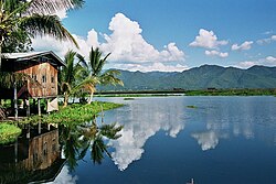
Inle Lake (Burmese: အင်းလေးကန်, MLCTS: ang: le: kan, [ʔɪ́ɰ̃lé kàɰ̃]) is a freshwater lake located in the Nyaungshwe Township of Shan State, part of Shan Hills in Myanmar (Burma). It is the second largest lake in Myanmar, with an estimated surface area of 44.9 square miles (116 km2), and one of the highest at an elevation of 2,900 feet (880 m). During the dry season, the average water depth is 7 feet (2.1 m), with the deepest point being 12 feet (3.7 m). During the rainy season, this can increase by 5 feet (1.5 m).
The watershed area for the lake lies to a large extent to the north and west of the lake. The lake drains through the Nam Pilu or Balu Chaung on its southern end. There is also a hot spring on its northwestern shore. (Full article...) -
Nga Tet Pya (Burmese: ငတက်ပြား, [ŋə tɛʔ pjá], also [ŋə dɛʔ bjá]; also spelled Ngatetpya or Nga Tat Pya) was a 14th-century Burmese outlaw who later became a commander in the royal army during the reign of King Thado Minbya of Ava. A well-known folkloric figure in Burmese culture, he is remembered as a Robin Hood-like character, who robbed the rich, and shared his loot with the poor. He is also known as the husband of Chantha, who is venerated by believers as the Amay Gyan nat spirit. (Full article...)

.JPG?lang=en)


.svg?lang=en)
.jpg?lang=en)
Did you know (auto-generated) -

- ... that Maung O, Prince of Salin, and his sister Nanmadaw Me Nu became de facto rulers of Burma when King Bagyidaw was suffering from depression?
- ... that the Burmese Buddhist monk Sagyo Thu-Myat successfully lobbied for the recalibration of the Burmese calendar?
- ... that Myinsaing withstood a ten-week siege by the Mongols because its three brother leaders bribed the invaders to withdraw?
- ... that Thinzar Shunlei Yi hid in the Burmese jungle for a month and joined a rebel militia following the 2021 Myanmar coup d'état?
- ... that while defending Zaw Myint Maung following his arrest by the Myanmar junta, lawyer Ywet Nu Aung was herself arrested and charged?
- ... that Burma the elephant once escaped Auckland Zoo?
- ... that the DI MA-1 Mk. III rifle was made in Myanmar as a reverse-engineered copy of the Chinese QBZ-97?
- ... that Molly Burman resumed releasing music three years later after finding that "Happy Things" had accrued a million streams on Spotify?
Related portals and projects
General images -
-
 Boxing match, 19th-century watercolour (from Culture of Myanmar)
 -
 Myinhkin thabin - equestrian sport (from Culture of Myanmar)
 -
 Mountains near Pindaya on the Shan Plateau (from Geography of Myanmar)
 -

-
 A large fracture on the Mingun Pahtodawgyi caused by the 1839 Ava earthquake. (from Geography of Myanmar)
 -
 Sculpture of Myanmar mythical lion (from Culture of Myanmar)
 -
 Aerial view of a burned Rohingya village in Rakhine state, September 2017 (from History of Myanmar)
 -
 Two female musicians play the saung at a performance in Mandalay. (from Culture of Myanmar)
 -
 The shores of Irrawaddy River at Nyaung-U, Bagan (from Geography of Myanmar)
 -
 Portuguese ruler and soldiers mounting an elephant. Jan Caspar Philips (draughtsman and engraver). (from History of Myanmar)
 -
 Grandfather Island, Dawei (from Geography of Myanmar)
 -
 A wedding procession, with the groom and bride dressed in traditional Burmese wedding clothes, reminiscent of royal attire (from Culture of Myanmar)
 -
 Vegetable stall on the roadside at the Madras Lancer Lines, Mandalay, January 1886. Photographer: Hooper, Willoughby Wallace (1837–1912). (from History of Myanmar)
 -
 British soldiers on patrol in the ruins of the Burmese town of Bahe during the advance on Mandalay, January 1945 (from History of Myanmar)
 -
 A wide range of Burmese lacquerware from Bagan (from Culture of Myanmar)
 -
 Temples at Mrauk U, the capital of the Mrauk U Kingdom, which ruled over what is now Rakhine State (from History of Myanmar)
 -

-
 First Anglo-Burmese War in 1824 (from History of Myanmar)
 -
 Aung San Suu Kyi addresses crowds at the NLD headquarters shortly after her release. (from History of Myanmar)
 -
 A bull fight, 19th-century watercolour (from Culture of Myanmar)
 -

-
 Political map of Burma (Myanmar) c. 1450 CE. (from History of Myanmar)
 -
 19th-century funeral cart and spire, which would form part of the procession from the home to the place of cremation (from Culture of Myanmar)
 -
 Protesters in Yangon carrying signs reading "Free Daw Aung San Suu Kyi" on 8 February 2021 (from History of Myanmar)
 -
 Pagan Kingdom during Narapatisithu's reign. Burmese chronicles also claim Kengtung and Chiang Mai. Core areas shown in darker yellow. Peripheral areas in light yellow. Pagan incorporated key ports of Lower Burma into its core administration by the 13th century. (from History of Myanmar)
 -
 Myanmar (Burma) map of Köppen climate classification (from Geography of Myanmar)
 -
 Recorder's Court on Sule Pagoda Road, with the Sule Pagoda at the far end, Rangoon, 1868. Photographer: J. Jackson. (from History of Myanmar)
 -
 British soldiers remove their shoes at the entrance of Shwedagon Pagoda. To the left, a sign reads "Foot wearing is strictly prohibited" in Burmese, English, Tamil, and Urdu. (from Culture of Myanmar)
 -
 The paddle steamer Ramapoora (right) of the British India Steam Navigation Company on the Rangoon river having just arrived from Moulmein. 1895. Photographers: Watts and Skeen. (from History of Myanmar)
 -
 Saint Mary's Cathedral in Downtown Yangon is the largest Roman Catholic cathedral in Burma. (from Culture of Myanmar)
 -
 Mount Popa, a dormant volcano in the Central Lowlands (from Geography of Myanmar)
 -
 A theatrical performance of the Mon dance (from Culture of Myanmar)
 -
 Hlei pyaingbwè - a Burmese regatta (from Culture of Myanmar)
 -
 British soldiers dismantling cannons belonging to King Thibaw's forces, Third Anglo-Burmese War, Ava, 27 November 1885. Photographer: Hooper, Willoughby Wallace (1837–1912). (from History of Myanmar)
 -

-
 Jade Mine in Hpakant (from Geography of Myanmar)
 -
![Image 37Military situation in Myanmar as of 2024[update]. Areas controlled by the Tatmadaw are highlighted in red. (from History of Myanmar)](https://upload.wikimedia.org/wikipedia/commons/thumb/c/c1/Myanmar_civil_war.svg/120px-Myanmar_civil_war.svg.png) Military situation in Myanmar as of 2024[update]. Areas controlled by the Tatmadaw are highlighted in red. (from History of Myanmar)
Military situation in Myanmar as of 2024[update]. Areas controlled by the Tatmadaw are highlighted in red. (from History of Myanmar) -
 A group of Buddhist worshipers at Shwedagon Pagoda, an important religious site for Burmese Buddhists (from Culture of Myanmar)
 -
 Former US President Barack Obama poses barefoot on the grounds of Shwedagon Pagoda, one of Myanmar's major Buddhist pilgrimage sites. (from Culture of Myanmar)
 -
 Protesters in Yangon with a banner that reads "non-violence: national movement" in Burmese. In the background is Shwedagon Pagoda. (from History of Myanmar)
 -
 Salween river at Mae Sam Laep on the Thai-Myanmar border (from Geography of Myanmar)
 -
 The restored Taungoo or Nyaungyan dynasty, c. 1650 CE (from History of Myanmar)


.jpg?lang=en)
_headquarter.jpg?lang=en)


![Image 37Military situation in Myanmar as of 2024[update]. Areas controlled by the Tatmadaw are highlighted in red. (from History of Myanmar)](/wiki/File:Myanmar_civil_war.svg?lang=en)


Major topics
Categories

More topics

Associated Wikimedia
The following Wikimedia Foundation sister projects provide more on this subject:
-
 Commons
Free media repository -
 Wikibooks
Free textbooks and manuals -
 Wikidata
Free knowledge base -
 Wikinews
Free-content news -
 Wikiquote
Collection of quotations -
 Wikisource
Free-content library -
 Wikiversity
Free learning tools -
 Wikivoyage
Free travel guide -
 Wiktionary
Dictionary and thesaurus


