Portal:Maps
| Main page | Maps |
The Maps and Cartography Portal

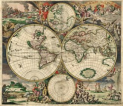
A map is a symbolic depiction of interrelationships, commonly spatial, between things within a space. A map may be annotated with text and graphics. Like any graphic, a map may be fixed to paper or other durable media, or may be displayed on a transitory medium such as a computer screen. Some maps change interactively. Although maps are commonly used to depict geographic elements, they may represent any space, real or fictional. The subject being mapped may be two-dimensional such as Earth's surface, three-dimensional such as Earth's interior, or from an abstract space of any dimension.
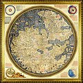
Maps of geographic territory have a very long tradition and have existed from ancient times. The word "map" comes from the medieval Latin: Mappa mundi, wherein mappa meant 'napkin' or 'cloth' and mundi 'of the world'. Thus, "map" became a shortened term referring to a flat representation of Earth's surface. (Full article...)
Cartography (/kɑːrˈtɒɡrəfi/) is the study and practice of making and using maps. Combining science, aesthetics and technique, cartography builds on the premise that reality (or an imagined reality) can be modeled in ways that communicate spatial information effectively. (Full article...)
Selected article -
Google Earth is a web and computer program created by Google that renders a 3D representation of Earth based primarily on satellite imagery. The program maps the Earth by superimposing satellite images, aerial photography, and GIS data onto a 3D globe, allowing users to see cities and landscapes from various angles. Users can explore the globe by entering addresses and coordinates, or by using a keyboard or mouse. The program can also be downloaded on a smartphone or tablet, using a touch screen or stylus to navigate. Users may use the program to add their own data using Keyhole Markup Language and upload them through various sources, such as forums or blogs. Google Earth is able to show various kinds of images overlaid on the surface of the Earth and is also a Web Map Service client. In 2019, Google revealed that Google Earth covers more than 97 percent of the world.
In addition to Earth navigation, Google Earth provides a series of other tools through the desktop application, including a measure distance tool. Additional globes for the Moon and Mars are available, as well as a tool for viewing the night sky. A flight simulator game is also included. Other features allow users to view photos from various places uploaded to Panoramio, information provided by Wikipedia on some locations, and Street View imagery. The web-based version of Google Earth also includes Voyager, a feature that periodically adds in-program tours, often presented by scientists and documentarians. (Full article...)
General images -
Selected quote
| “ | The map is not the territory ... The only usefulness of a map depends on similarity of structure between the empirical world and the map... | ” |
| — Alfred Korzybski | ||
Related portals
Related WikiProjects
Selected biography -
Captain George Comer (April 1858 – 1937) was considered the most famous American whaling captain of Hudson Bay, and the world's foremost authority on Hudson Bay Inuit in the early 20th century.
Comer was a polar explorer, whaler/sealer, ethnologist, cartographer, author, and photographer. He made 14 Arctic and three Antarctic voyages in his lifetime. These expeditions (ca. 1875–1919) commonly began in New London, Connecticut or New Bedford, Massachusetts. Comer's circle of friends and colleagues included other notable explorers of the time, such as Robert Peary and Capt. Frederick Cook, and his mentor, Franz Boas, the "Father of American Anthropology". (Full article...)
Selected picture

Did you know
- ... that the Canadian League for Peace and Democracy organized a 10,000-person rally at Maple Leaf Gardens in Toronto to protest a 2,500-person fascist rally?
- ... that Maki Narukido researched the characters' travel times in her manga The End of the World With You using Google Maps?
- ... that Kathryn Maple won the Sunday Times Watercolour Competition twice in three years?
- ... that the 100 gecs tree was listed as a "place of worship" on Google Maps?
- ... that DeepStateMap.Live, an interactive map of the Russian invasion of Ukraine, received up to 120,000 visitors in 30 minutes during the Battle of Izium in the 2022 Kharkiv counteroffensive?
Topics
Map - Atlas - Geography - Topography
Cartography: Cartographers - History of cartography - Ancient world maps - World maps - Compass rose - Generalization - Geographic coordinate system - Geovisualization - Relief depiction - Scale - Terra incognita - Planetary cartography
Map projection: Azimuthal equidistant - "Butterfly" - Dymaxion - Gall–Peters - General Perspective - Goode homolosine - Mercator - Mollweide - Orthographic - Peirce quincuncial - Robinson - Sinusoidal - Stereographic
Maps: Animated mapping - Cartogram - Choropleth map - Estate map - Geologic map - Linguistic map - Nautical chart - Pictorial map - Reversed map - Road atlas - Thematic map - Topographic map - Weather map - Web mapping - World map
Map examples
World

Historical
Thematic
Geographic

Political

Nautical
Categories
Things you can do
|
Here are some Geography related tasks you can do:
|
Atlases and maps of the world at Wikimedia Commons
Associated Wikimedia
The following Wikimedia Foundation sister projects provide more on this subject:
-
Commons
Free media repository -
Wikibooks
Free textbooks and manuals -
Wikidata
Free knowledge base -
Wikinews
Free-content news -
Wikiquote
Collection of quotations -
Wikisource
Free-content library -
Wikiversity
Free learning tools -
Wiktionary
Dictionary and thesaurus


