
Rosebud, Texas
Rosebud, Texas | |
|---|---|
.jpg?lang=simple) Downtown Rosebud | |
 Location of Rosebud, Texas | |
 | |
| Coordinates: 31°04′32″N 96°58′30″W / 31.07556°N 96.97500°W | |
| Country | |
| State | |
| County | Falls |
| Area | |
| • Total | 0.81 sq mi (2.09 km2) |
| • Land | 0.80 sq mi (2.08 km2) |
| • Water | 0.00 sq mi (0.00 km2) |
| Elevation | 407 ft (124 m) |
| Population (2020) | |
| • Total | 1,296 |
| • Density | 1,677.86/sq mi (647.89/km2) |
| Time zone | UTC-6 (Central (CST)) |
| • Summer (DST) | UTC-5 (CDT) |
| ZIP code | 76570 |
| Area code | 254 |
| FIPS code | 48-63188[3] |
| GNIS feature ID | 2410996[2] |
| Website | www |
Rosebud is a city in Falls County, Texas, United States. As of the 2020 United States census, 1,296 people lived there.
References
[change | change source]- ↑ "2019 U.S. Gazetteer Files". United States Census Bureau. Retrieved August 7, 2020.
- 1 2 U.S. Geological Survey Geographic Names Information System: Rosebud, Texas
- ↑ "U.S. Census website". United States Census Bureau. Retrieved January 31, 2008.
Municipalities and communities of Falls County, Texas, United States | ||
|---|---|---|
| Cities | 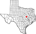 | |
| CDP | ||
| Other communities | ||
| Ghost towns | ||
| Footnotes | ‡This populated place also has portions in an adjacent county or counties | |