
Parasnath
| Parasnath | |
|---|---|
| Sammet Shikhar[1]Marang Buru[2][3][4] | |
 Parasnath Hill | |
| Highest point | |
| Elevation | 1,365 m (4,478 ft) |
| Prominence | 1,017 m (3,337 ft) |
| Listing | List of Indian states and territories by highest point, Ribu |
| Coordinates | 23°57′48″N 86°07′44″E / 23.9634°N 86.129°E[5] |
| Naming | |
| Native name | Sarak bhumi (Sanskrit) |
| Geography | |
 Parasnath Location of Parasnath peak in Jharkhand | |
| Location | Pirtand CD Block, Giridih, Jharkhand, India |
| Parent range | Parasnath Range |
Parasnath Hill (also Sammet Shikhar, Marang Buru) is a mountain peak in the Parasnath hill range.[4] It is located towards the eastern end of the Chota Nagpur Plateau in the Giridih district (Hazaribagh district in British India) of the Indian state of Jharkhand.[6] The hill is named after Parshvanatha, the 23rd Jain Tirthankara, who attained liberation here in 8th century BCE.[3] In this connection, there is the holiest Jain pilgrimage, Shikharji on the top of hill. The hill is also known as Sammet Shikhar (lit. 'great mountain', the supreme deity) by other autochthonous of the region in religious contexts.[1][7][8]
Geography
[edit]
9.9miles
River
River
M: municipality, C: census town, R: rural/ urban centre, H: historical/ religious/ tourist centre
Click or prolonged tap on icons for detail. Owing to space constraints, the locations on click through to the larger map may vary slightly.
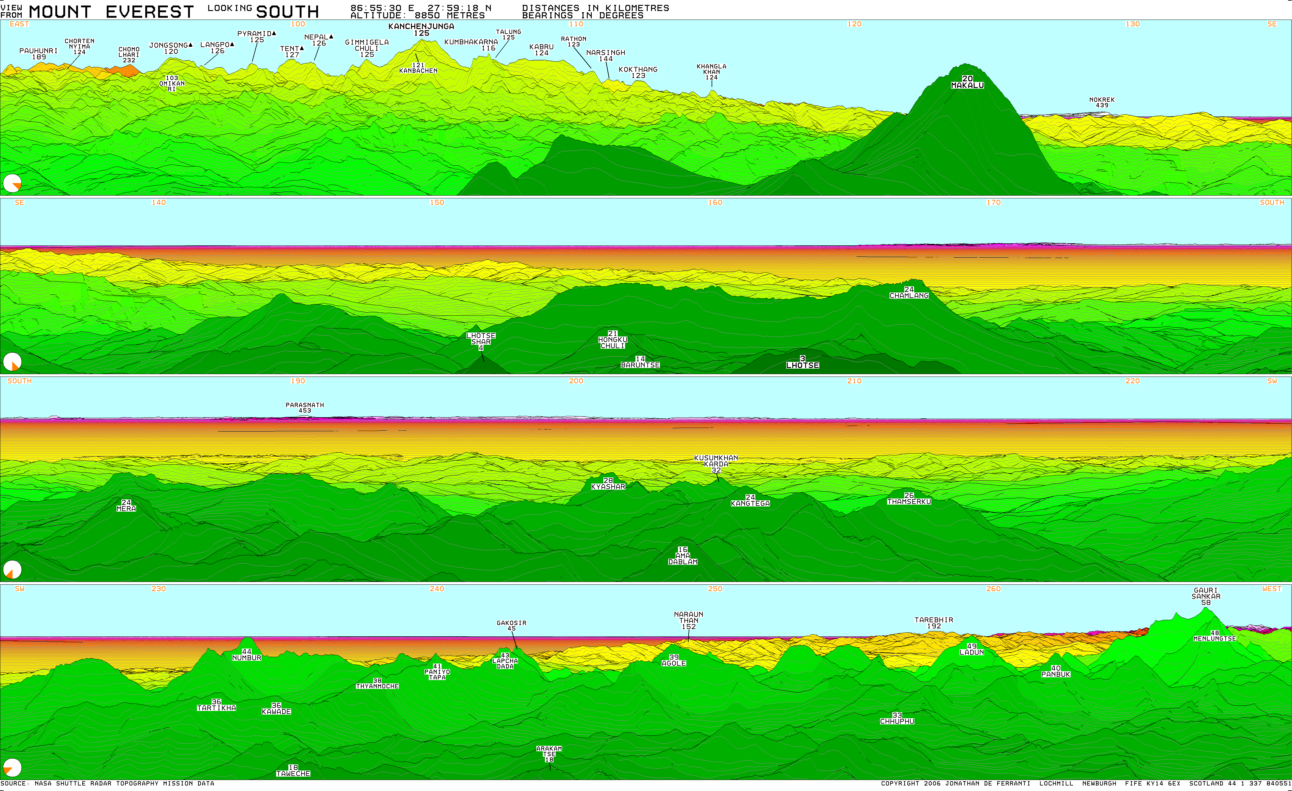
At 1,365 m (4,478 ft) Parasnath is the highest mountain peak in the state of Jharkhand, and is theoretically inter-visible (by direct line of sight on a perfectly clear day) with Mount Everest over 450 km (280 mi) away.[9] The foothills of the Himalayas are about 180 miles away to the north over the Ganges.[10]
There is a Jain temple on the mountain peak known as "Svarna Bhadra koot " ("cottage of golden grace").[11] The temple is made of marble. There is another marble Jain temple on hill, known as Jal Mandir.
It is easily accessible from Parasnath railway station.
Geology
[edit]The underlying rock is metamorphosed fine-grained sedimentary rock with granodiorite igneous intrusions through these older formations.[12]
Fauna
[edit]As originally described several landsnails were only found in the Parasnath Hills area but the fauna is otherwise typical for Bengal.[10]
History
[edit]| Part of a series on |
| Jainism |
|---|
 |
Historically, Parasnath or Sammet Shikharji has been an ancient Jain pilgrimage site. It is a place where the 23rd tirthankara Parshvanath (also known as Parasnath) attained liberation here in 772 BCE. It is noteworthy that the name of the Parasnath hill derived from the Jain Tirthankar Parshvanath who is also known as Parasnath or Parsva who attained liberation here during the 8th century BCE. After preaching for 70 years, Parshvanath attained moksha at Shikharji on Parasnath hill. Some Jain texts name the place as Mount Sammeta.[13] It is the most revered in Jainism because 20 of its 24 tirthankars are believed to have attained moksha there.[14][15][16] at the age of 100 on Shravana Shukla Saptami according to Lunar Calendar.[17] His moksha (liberation from the cycle of birth and death) in Jain tradition[18] is celebrated as Moksha Saptami. This day is celebrated on large scale at Parasnath tonk of the mountain, in northern Jharkhand, part of the Parasnath Range[19] by offering Nirvana Laddu (Sugar balls) and reciting of Nirvana Kanda. Parshvanatha has been called purisādāṇīya (beloved of the people) by Jains.[20][21][22]
The earliest literary reference to Shikharji (Parasnath) as a tirth (place of Jain pilgrimage) is found in the Jñātṛdhārmakātha, one of the twelve core texts of Jainism compiled in 6th century BCE by chief disciple of Mahavira. Shikharji is also mentioned in the Pārśvanāthacarita, a twelfth-century biography of Pārśva. A 13th century CE palm-leaf manuscript of Kalpa Sūtra and Kalakacaryakatha has an image of a scene of Parshavanatha's nirvana at Shikharji.[23] This all indicates Parasnath was a Jain site since ancient times. Also many historians accept Parasnath as the place of Nirvan Kalyanak of the historical figure and the 23rd Tirthankar, Parshvanath.[24][17][25][26]
Jain heritage
[edit]This is one of the most holy and revered sites for the Jain community. They call it Sammed Sikhar. It is a major pilgrimage site. Out of 24 Tirthankaras of Jains, twenty attained nirvana at Parshvnatha Hills.
On the mountain, there are the Shikharji Jain temples, an important tirthakshetra or Jain pilgrimage site.[27] For each Tirthankara there is a shrine (gumti or Tonk) on the hill.[28]
The Jain temple is believed to be constructed either by the Magadha King Bimbisara or by the Kalinga King Avakinnayo Karakandu.
An ancient idol of Parasnath is located in the valley at Palganj. The idol is believed to be 2500 years old.[29]
During 772 BCE at the age of 100 on Shravana Shukla Saptami according to Lunar Calendar.[17] Tirthankar Parswanath moksha (liberation from the cycle of birth and death) in Jaina tradition[18] is celebrated as Moksha Saptami. This day is celebrated on large scale at Parasnath tonk of the mountain, in northern Jharkhand, part of the Parasnath Range[19] by offering Nirvana Laddu (Sugar balls) and reciting of Nirvana Kanda.
Santhal heritage
[edit]The local Santhal community, which comprises 26% of the population of Jharkhand, use the name Marang Buru to refer to both their deity and the mountain.[4] They are in dispute with the Jain community as to certain ancestral worship and other rights, and these have been subject to judicial review historically.[2] Recent bans on meat and alcohol, upheld by the Jharkhand High Court in 2025, have exacerbated the conflict, curtailing Santal traditions and fueling protests and counter-petitions in the court.[30] However Jains claim that Santhal claim is implausible and illogical and that actually Parasnath is a Jain pilgrimage since ancient times. They also observe that Jains and Adivasis have co-existed at Parasnath Hill since ancient times, and that when the tirthankaras sought nirvana there, Adivasis traditionally carried them to the summit, a practice that continues today.[30]
See also
[edit]-
 Shwetambar temple of Parshwanath at foothills of Parasnath hill
 -
 Foot idol of Parasnath
 -
 "Swarna Bhadra Koot" Temple of Parasnath on mountain peak
 -
 Notice board on mountain
 -
 Waterfall on hill
 -
 "Jal Mandir", a Jain temple over hill
 -
 Temples in valley
 -
 Idol of Pushpadant


References
[edit]- ^ a b Choudhury, Pranab Chandra Roy (1975). Bihar. Publications Division, Ministry of Information and Broadcasting, Government of India. p. 60.
- ^ a b Deogharia, Jaideep (9 February 2025). "Santhals join hands to claim right over Marang Buru". Archived from the original on 19 February 2025. Retrieved 27 April 2025.
- ^ a b "Parasnath / Marang Buru | DISTRICT GIRIDIH, GOVERNMENT OF JHARKHAND | India".
- ^ a b c Soren, A.A.; Singh, S. (26 September 2024). "'Adi-dharam': Tribal Philosophy about Jharkhand's Culture and its Struggle for Sustainable Existence". International Journal of Advance Studies and Growth Evaluation. 3 (8): 8–13.
- ^ Parasnath Hill
- ^ "Official website of the Giridih district". Retrieved 7 March 2012.
- ^ Indian Antiquary. Popular Prakashan. 1893. p. 295.
- ^ Transactions. India Mining, Geological, and Metallurgical Institute of. 1937. p. 61.
- ^ "View from Mt. Everest looking south". ViewfinderPanoramas.org. Retrieved 3 June 2024.
- ^ a b Annandale, N. (1912). "Notes on the Fauna of Paresnath Hill, Western Bengal". Records of the Zoological Survey of India: 3–49.
- ^ "Shri Sammed Shikharji - Encyclopedia of Jainism". 21 January 2023. Retrieved 3 May 2023.
- ^ Sinha, R.C.; Dave, V.K.S. (1963). "Effect of Granitic Emplacement on Epidiorites of Parasnath Area, (Bihar) India". GSA Bulletin. 74 (9): 1143–1154. doi:10.1130/0016-7606(1963)74[1143:EOGEOE]2.0.CO;2.
- ^ Jacobi 1964, p. 275.
- ^ Cort 2010, pp. 130–133.
- ^ Wiley 2009, p. 148.
- ^ Dundas 2002, p. 221.
- ^ a b c Dundas 2002, p. 30.
- ^ a b Sangave 2001, p. 104.
- ^ a b Kailash Chand Jain 1991, p. 13.
- ^ Jacobi 1964, p. 271 with footnote 1.
- ^ Kailash Chand Jain 1991, pp. 12–13.
- ^ Schubring 1964, p. 220.
- ^ Eastman 1943, p. 95.
- ^ Balfour 1885, p. 141.
- ^ Sangave 2001, p. 103.
- ^ University of Calcutta 1845, p. 256.
- ^ "Shikharji." Jain V. Herenow4u.net Accessed 26 May 2012
- ^ "Parasnath | DISTRICT GIRIDIH, GOVERNMENT OF JHARKHAND | India".
- ^ "The forgotten taleti of Shikharji - Palganj". 15 January 2020. Retrieved 3 May 2023.
- ^ a b "Story of a sacred Jharkhand hill at the centre of old friction between Jains & Santals". The Indian Express. 17 May 2025. Retrieved 23 May 2025.
Sources
[edit]- Jacobi, Hermann (1964), Max Muller (The Sacred Books of the East Series, Volume XXII) (ed.), Jain Sūtras (Translation), Motilal Banarsidass (Original: Oxford University Press)
- Cort, John E. (2010), Framing the Jina: Narratives of Icons and Idols in Jain History, Oxford University Press, ISBN 978-0-19-538502-1
- Dundas, Paul (2002) [1992], The Jains (Second ed.), London and New York: Routledge, ISBN 978-0-415-26605-5
- Wiley, Kristi L. (2009), The A to Z of Jainism, vol. 38, Scarecrow, ISBN 978-0-8108-6337-8
- Sangave, Vilas Adinath (2001), Facets of Jainology: Selected Research Papers on Jain Society, Religion, and Culture, Mumbai: Popular Prakashan, ISBN 978-81-7154-839-2

- Jain, Kailash Chand (1991), Lord Mahāvīra and His Times, Motilal Banarsidass, ISBN 978-81-208-0805-8
- Schubring, Walther (1964), Jinismus, in: Die Religionen Indiens, vol. 3, Stuttgart
- Eastman, Alvan C. (1943). "Iranian Influences in Śvetāmbara Jaina Painting in the Early Western Indian Style". Journal of the American Oriental Society. 63 (2): 93–113. doi:10.2307/594116. JSTOR 594116. Retrieved 6 May 2022.
- Balfour, Edward (1885), The Cyclopædia of India and of Eastern and Southern Asia, vol. 1, B. Quartitc
- University of Calcutta (1845). Calcutta Review. Vol. 3. University of Calcutta.