
Moulsoe
| Moulsoe | |
|---|---|
 The Parish Church - St Mary's of the Assumption | |
 Moulsoe Location within Buckinghamshire | |
 Interactive map of Moulsoe | |
| Population | 318 (2011 Census)[1] |
| OS grid reference | SP910419 |
| Civil parish |
|
| District | |
| Unitary authority | |
| Ceremonial county | |
| Region | |
| Country | England |
| Sovereign state | United Kingdom |
| Post town | NEWPORT PAGNELL |
| Postcode district | MK16 |
| Dialling code | 01908 |
| Police | Thames Valley |
| Fire | Buckinghamshire |
| Ambulance | South Central |
| UK Parliament | |
Moulsoe is a village and civil parish in the unitary authority area of the City of Milton Keynes, Buckinghamshire, England.[2] It is on the border with Bedfordshire, and just east of the M1, situated about 2.5 miles (4.0 km) ESE of Newport Pagnell, and about 5 miles (8.0 km) NNE of Central Milton Keynes. The main road through the village is the Newport Road coming from the west, changing to the Cranfield Road going east at a bend by the church.
The village name is an Old English language word which means 'Mul's hill spur'.[3] In the Domesday Book of 1086 the village was recorded as Moleshou.[4]
At the 2011 Census, the population of the parish was 318,[1] down slightly from 330 at the 2001 census.[5] As of 2019[update], the parish is mainly rural but a large area just west of the village has been identified for future expansion of Milton Keynes.[6]
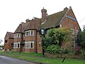
There are several old thatched dwellings. Other buildings are of brick apart from some concrete council houses to the west. The parish church dates from the 14th century and is a Grade I listed building.[7] There is an inn, the Carrington Arms, and a village hall, the Millennium Hall.[8]
Caldecote
[edit]Caldecote is a tiny hamlet in the parish, notable because of it being mentioned in Domesday.[9]
Gallery
[edit]-
 Yew Tree Cottage, Newport Road
 -
 The Carrington Arms, Cranfield Road
 -
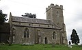 St Mary's church, view from Newport Road


References
[edit]- ^ a b UK Census (2011). "Local Area Report – Moulsoe (E04001264)". Nomis. Office for National Statistics. Retrieved 19 November 2019.
- ^ "Contact your Parish, Town or Community Council". Milton Keynes Council. Retrieved 10 October 2020.
- ^ "Key to English place names". Institute for Name-Studies, University of Nottingham. Retrieved 15 November 2025.
- ^ moulsoe.net/history.htm
- ^ http://www.mkweb.co.uk/statistics/documents/Population%5FBulletin%5F2005%2D6%2Epdf Archived 11 September 2006 at the Wayback Machine, page 22
- ^ Jessica MacKinnon (11 August 2019). "Milton Keynes East Development Framework". communityactionmk.org. Retrieved 19 November 2019.
- ^ Historic England (17 November 1966). "Church of St. Mary (1212922)". National Heritage List for England. Retrieved 15 November 2025.
- ^ www.milton-keynes.gov.uk Archived 2012-12-23 at archive.today Moulsoe Millennium Hall
- ^ "Buckinghamshire A-E". The Domesday Book Online. Retrieved 23 November 2022.
External links
[edit]![]() Media related to Moulsoe at Wikimedia Commons
Media related to Moulsoe at Wikimedia Commons
This Buckinghamshire location article is a stub. You can help Wikipedia by expanding it. |