Logan County, Arkansas
Logan County | |
|---|---|
,_Paris,_AR_002.jpg?lang=simple) Logan County Courthouse, Paris | |
 Location within the U.S. state of Arkansas | |
 Arkansas's location within the U.S. | |
| Coordinates: 35°13′29″N 93°44′26″W / 35.224722222222°N 93.740555555556°W | |
| Country | |
| State | |
| Founded | March 22, 1871 |
| Named for | James Logan |
| Seat | Paris (northern district); Booneville (southern district) |
| Largest city | Booneville |
| Area | |
| • Total | 732 sq mi (1,900 km2) |
| • Land | 708 sq mi (1,830 km2) |
| • Water | 23 sq mi (60 km2) 3.2% |
| Population | |
| • Total | 21,131 |
| • Density | 29/sq mi (11/km2) |
| Time zone | UTC−6 (Central) |
| • Summer (DST) | UTC−5 (CDT) |
Logan County (formerly Sarber County) is a county of the U.S. state of Arkansas. As of the 2020 census, the population was 21,131.[1] The county seats are Booneville and Paris.[2] It was founded on March 22, 1871.
References
[change | change source]- 1 2 "QuickFacts: Logan County, Arkansas". United States Census Bureau. Retrieved August 8, 2023.
- ↑ "Find a County". National Association of Counties. Retrieved 2011-06-07.
Municipalities and communities of Logan County, Arkansas, United States | ||
|---|---|---|
| Cities | 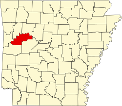 | |
| Towns | ||
| CDP | ||
| Unincorporated communities | ||