
File:Niger - Location Map (2011) - NER - UNOCHA.svg

_-_NER_-_UNOCHA.svg)
Somario
| Descrision |
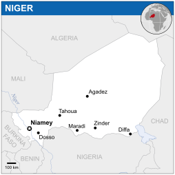
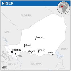
English: Locator map of Niger. |
| Data | |
| Provenjiensa |
English: Niger Locator Map (ReliefWeb) |
| Autore | |
| SVG sviluppo |
Licensa de doparasion:
- Te si libaro:
- de spartire in jiro – de copiar, distribuir e trasmétar sta opera
- de modifegar – de adatar sta opera
- Soto le seguenti condision:
- atribussion – Te ghe da atribuir ƚa paternità de ƚ'opera ne i modi indicà de l'autor o da chi te gà dà l'opera en lisensa, e en modo tale da no sugerir che lori i sia d'acordo con ti o col modo che te dòpari l'opera.
 This map is part of a collection of 216 free country maps, created by the UN Office for the Coordination of Humanitarian Affairs (OCHA), to be used in print, web or broadcast products.
The ReliefWeb Location Maps released here are maps that highlight a country, its capital, major populated places and the surrounding regions. Attribution Requirements
Using the map without modifications: ensure that the sources and the disclaimer are below the map. Credit as follows: "Credit: OCHA". For use with alteration: remove the OCHA logo and disclaimer following any modification to the map, but keep the data sources as mentioned below the map. Credit the modified map as follows: "Based on OCHA map". You are responsible for the content of your map. We are keen to receive your feedback and hear how you used OCHA's maps. We would be grateful if you would notify us by e-mail and share your work with us. UN Disclaimer
The designations employed and the presentation of material of this map do not imply the expression of any opinion whatsoever on the part of the Secretariat of the United Nations concerning the legal status of any country, territory, city or area or of its authorities or concerning the delimitation of its frontiers or boundaries. |
Istoria del file
Schicia so on grupo data/or pa vedare el file come che el se presentava in tel momento indegà.
| Data/Ora | Miniadura | Dimension | Utente | Comento | |
|---|---|---|---|---|---|
| In ultima | 04:33, 18 nov 2014 | | 254 × 254 (342 KB) | Pharos | try without logo for now |
| 01:05, 8 maj 2014 |  | 254 × 254 (338 KB) | UN OCHA maps bot | == {{int:filedesc}} == {{Information |description={{en|1=Locator map of Niger.}} |date=2011 |source={{en|1=[http://reliefweb.int/map/niger/niger-location-map-2011 Niger Locator Map (ReliefWeb)]}} |author={{en|1=[[w:en:United Nations Offi... |
Doparasion del file
Ła pajina che vien ła dopara sto file:
Doparasion globałe del file
St'altre wiki cua le dopara sto file:
- Uxo de arz.wikipedia.org inte le pàjine
- Uxo de ast.wikipedia.org inte le pàjine
- Uxo de azb.wikipedia.org inte le pàjine
- Uxo de bh.wikipedia.org inte le pàjine
- Uxo de bn.wikipedia.org inte le pàjine
- Uxo de ca.wikipedia.org inte le pàjine
- Uxo de dag.wikipedia.org inte le pàjine
- Uxo de de.wikivoyage.org inte le pàjine
- Uxo de dga.wikipedia.org inte le pàjine
- Uxo de diq.wikipedia.org inte le pàjine
- Uxo de eo.wikinews.org inte le pàjine
- Uxo de es.wikipedia.org inte le pàjine
- Uxo de ff.wikipedia.org inte le pàjine
- Uxo de fr.wikinews.org inte le pàjine
- Uxo de ga.wikipedia.org inte le pàjine
- Uxo de gl.wikipedia.org inte le pàjine
- Uxo de gpe.wikipedia.org inte le pàjine
- Uxo de ha.wikipedia.org inte le pàjine
- Uxo de he.wikivoyage.org inte le pàjine
- Uxo de ht.wikipedia.org inte le pàjine
- Uxo de hu.wikipedia.org inte le pàjine
- Uxo de ia.wikipedia.org inte le pàjine
- Uxo de id.wikipedia.org inte le pàjine
- Uxo de ig.wikipedia.org inte le pàjine
- Uxo de ilo.wikipedia.org inte le pàjine
- Uxo de incubator.wikimedia.org inte le pàjine
- Uxo de kab.wikipedia.org inte le pàjine
- Uxo de knc.wikipedia.org inte le pàjine
- Uxo de lb.wikipedia.org inte le pàjine
- Uxo de mos.wikipedia.org inte le pàjine
- Uxo de ms.wikipedia.org inte le pàjine
- Uxo de ne.wikipedia.org inte le pàjine
- Uxo de pl.wikipedia.org inte le pàjine
- Uxo de rue.wikipedia.org inte le pàjine
- Uxo de sco.wikipedia.org inte le pàjine
- Uxo de sd.wikipedia.org inte le pàjine
- Uxo de shi.wikipedia.org inte le pàjine
- Uxo de te.wikipedia.org inte le pàjine
- Uxo de tt.wikipedia.org inte le pàjine
- Uxo de www.wikidata.org inte le pàjine
_-_NER_-_UNOCHA.svg?lang=vec)