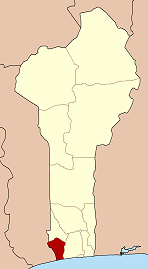
Bopa
Bopa | |
|---|---|
| Coordinates: 6°35′N 1°59′E / 6.583°N 1.983°E | |
| Country | |
| Department | Mono Department |
| Government | |
| • Mayor | Abel Djossou |
| Area | |
• Total | 141 sq mi (365 km2) |
| Population (2002) | |
• Total | 70,268 |
| Time zone | UTC+1 (WAT) |

Bopa [bɔ.pa] is a town, arrondissement, and commune in the Mono Department of south-western Benin.The commune covers an area of 365 square kilometres and as of 2002 had a population of 70,268 people.[1][2]
Geography
[edit]Bopa is located in the Mono Department in south-western Benin, bordered by Lake Ahémé on the east and by the communes of Lokossa, Comé and Athiémé. [3] Lake Ahémé, one of Benin’s most important inland water bodies, plays a central role in the commune’s economy, especially fishing and tourism. The landscape is composed of low plateaus, sandy soils, hydromorphic depressions and mangrove zones along the lake’s shoreline.
Administrative structure
[edit]Bopa is one of the six communes of the Mono Department. It is administratively subdivided into several arrondissements, including: Bopa (central town), Gbakpodji, Lobogo, Agbodji, Yégodo-Houé, Adjaha; and several additional villages and urban districts. These arrondissements contain more than 60 villages collectively. [4]
Demographics
[edit]According to the 2013 RGPH-4 census, Bopa had 114,207 inhabitants, strongly surpassing the 2002 estimate of 70,268 inhabitants. [5] The population is composed primarily of the Sahouè, Xwla, Fon, and Kotafon ethnic groups, with smaller minorities of Mina and Adja people. Languages widely spoken are Sahouè, Xwla, Fon, Goun, and French.
Economy
[edit]Bopa’s economy is driven by a combination of:
- fishing, especially on Lake Ahémé (tilapia, catfish, shrimp)
- agriculture (maize, cassava, palm oil, tomatoes, okra)
- fish farming and salt extraction in some lake-adjacent areas
- tourism, particularly around Lake Ahémé, known for mangroves, canoe trips, and traditional fishing villages
Studies note that fishing and water-based activities involve more than half of the active population in some zones. [6] Artisanal salt production is also practiced in some coastal frameworks of the commune.
Culture
[edit]Bopa has a rich cultural landscape, marked by:
- traditional religions tied to water spirits and lagoon deities
- Voodoo practices linked to Lake Ahémé
- dance traditions such as Kpanlingan and Sahouè motifs
- yearly festivals including harvest celebrations and river ceremonies
Cultural studies highlight that Bopa maintains some of the most active traditional chieftaincies in the Mono region. [7]
Transport
[edit]Bopa is connected by road to the communes of Lokossa (north), Athiémé (west) and Comé/Grand-Popo (south). The commune lies within the broader Lake Ahémé tourism circuit, attracting visitors through its lagoon villages and canoe routes. During heavy rains, rural roads near the lake become difficult to navigate.
Public services
[edit]The commune has a network of public primary schools, a number of secondary establishments, and several community health centers. Drinking water is supplied through boreholes, standpipes and small-piped water systems, supported by national rural hydraulic programs. [8] Electricity access is improving across the commune due to extensions of the national grid funded by development partners.
References
[edit]- ^ "Bopa". Atlas Monographique des Communes du Benin. Archived from the original on May 9, 2021. Retrieved January 5, 2010.
- ^ "Communes of Benin". Statoids. Retrieved January 5, 2010.
- ^ "Communes of the Mono Region". Voyages Modestes. Retrieved 13 November 2025.
- ^ "Présentation administrative de Bopa". Ministère de la Décentralisation. Retrieved 13 November 2025.
- ^ "Bopa – Population Statistics". CityPopulation.de. Retrieved 13 November 2025.
- ^ "Évaluation du potentiel halieutique du lac Ahémé". HAL Open Science. Retrieved 13 November 2025.
- ^ "Culture du Mono". Ministère de la Culture. Retrieved 13 November 2025.
- ^ "Programme national d'accès à l'eau potable dans le Mono". Benin Water Initiative. Retrieved 13 November 2025.
6°35′N 1°59′E / 6.583°N 1.983°E


